17770 ft
14 days
Difficult
145 KM
18+ Years Old People
Experience of 1 high altitude trek of 15000 ft. is required
Covers 5 kms distance in 30 mins without any stress
Pokhra
Nepal
Pokhra
No Rail Connection
Pokhra
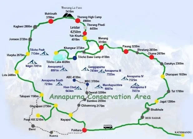
Round Trail starting and ending at Pokhra.
Summer : May, June Autumn : October, November Winter : December
December to April
Veg + Non Veg
Tea Houses and Guest houses
The Annapurna Circuit trek is a famous hiking route in Nepal that circles around the Annapurna Massif, one of the highest mountain ranges in the world. Here are some key points about it:
In addition to the photogenic corridors, the mountains you witness on the Annapurna Circuit Trek are so high, it is quite a task to distinguish between snow-clad peaks and the milk-white clouds – the peaks in the region truly reach for the stars and make it there! To add to the constant company of the mighty Annapurna massif and other 8000ers towering in your vicinity all along its route, glacial lakes are another addition to the trail’s very rich assortment of features. From Ice Lake (4,620M) half a day’s hike away from the beautiful village of Manang to Tilicho Lake at 4,920M bang in the middle of the Annapurna range of Himalayas, the trail for Annapurna Circuit Trek will have you swooning for its unimaginable beauty, and the surprises in terrain through and through. Along with the most diverse trekking landscapes of any trek in Nepal, the trek also offers distinct religious and cultural settlements high up in these folds of the Himalayas. From the lush, green Hindu villages at the foothills of these regions to the arid Buddhist lands with the colourful prayer flags sputtering to the high winds on the trail’s higher reaches, it’s as much of a cultural indulgence as it is a rendezvous with the illustriousness of Nepal Himalayas.
Overall, the Annapurna Circuit trek is renowned for its breathtaking scenery, cultural richness, and the physical challenge it presents, making it a bucket-list adventure for many trekkers around the world.
Today is your day 1 of the trek when you will be reporting at Pokhra in Nepal. Take your time and reach our designated hotel at Pokhra.
Over night stay at a guest house in 3/4 persons sharing basis.
Pokhra is a beautiful town by the side of famous Phewa Lake. After freshening up, have a lake side walk, enjoy local dishes and go for your last minute shopping for trek necessary items.
Have an early dinner and rest your body to embark on the next 8 days hectic journey.
Only Hotel accommodation is provided by us in a lakeside guest house with 3/4 persons sharing room with attached bathroom and hot shower.
Today after an early healthy breakfast we check out from hotel and start our journey for the trek.
The drive from Pokhara to Chame via Besisahar involves a scenic journey through diverse landscapes, passing through villages, rivers, and gradually ascending into the Annapurna region, taking around 7-8 hours depending on road conditions.
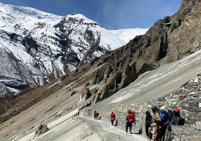
The entire route to Chame from Besisahar runs along the west bank of Marsyangdi River. Some trekkers choose to start their trek at Besisahar, and trek alongside this dramatic river all the way up to Chame. However, given that the trekking route is the same as the road, the clouds of dust every few seconds, from the passing vehicles on these dirt tracks, along with the fumes from the cars make it a less than pleasant hike. Hence, the better alternative is to drive up to Chame, give your body some time to acclimatize and start your trek from a less busy town.
Fifteen minutes into our drive from Besisahar, we get on a road flanked by forests and green mountains with rice and millet growing on terraced hillsides. Stone and mud houses painted in bold colours which are characteristic of settlements in Nepal are stippled all through the landscape. The river meandering below with the mountains on the other side patterned with houses, farms and farm animals spread across the lower flanks and thick forests on their higher reaches – 50 shades of green all the way through. As we go forward, the villages get smaller and farther apart before any sign of settlement completely disappears. You’ll see a lot of suspension bridges connecting the mountains on either side of the river for ease of movement for the locals. Waterfalls are aplenty all through the track, you’ll find one pouring out of a mountain-side every 20M or so. All the waterfalls make these muddy roads slushy and slippery with the accumulated water adding to the adventure. Three hours into the drive and you know you are nearing Chamje when you see the infamous Chamje waterfall. This is a good spot for some time out of the car before we carry on ahead.
Around 3 more hours from here and we are at 2,550M at a small village that goes by the name of Chame.
With the highest mountains stacked outside your wooden framed window and the sun peering from behind, turning them into all shades pastel to burnt red, Chame is a pleasant town to wake up in after a whole day of back-breaking drives on dirt roads. Lamjung Himal (6,983M) is especially handsome in the first morning light. Stone-walled houses and dirt roads with the river calling out with all its sounds, the sunsets in Chame are spectacular too as Manaslu North (7,157m), Manaslu (8,160m) and Phungi Himal (6,540m) rise skywards, glowing a fiery red in the dying twilight. Chame has well-stocked shops with a fair share of fried samosas and chips for all your seemingly unreasonable and untimely cravings. It also is the last town you might find a functioning ATM in, so if you need to withdraw some cash, do it today! There might be one at Manang too, but it is better to have two shots at withdrawing the much needed cash than one!
Today is our 1st day of walking on the trails. Today we cover approx 15 kms of distance in 7-8 hours. The trail is very scenic and marks some very unique and remarkable landmarks.
The trail starts out with alpine trees on both sides which climbs up gradually with small patches of descend. Mani stones and chortens are scattered along the trail. Mani stones are stone plates and rocks inscribed with Buddhist mantras adding to the inimitable vibe of the valley. They are placed alongside the roads and rivers or sometimes placed together to form a mound as an offering to the spirits of the place. The beliefs of the locals dictate that these structures be crossed from the left as a continuation of their belief of the universe revolving in a clockwise direction forming circular patterns which are seen as a repetitive pattern in all Buddhist customs.
At close to the three hour mark, we reach a suspension bridge to cross over to the other side of the river. These cantilever metal bridges dancing to the music of the winds are aplenty in all these regions of Nepal. Right after crossing the bridge, we go off the road and in to the pine forest to follow the old trail through these woods. The sharp sounds of various birds talking to the winds, the intoxicating sweet smell of the pines and the trance of the sparkling turquoise river down below are all a constant through this patch of the hike. We are gaining over 600M of altitude today – the entire route a relentless but steady slope upwards with patches of steep ascent.
One of the most fascinating things to watch out for on the trek today is Paungda Danda which stands out amongst all the splendid high mountains owning the entire view all through the trail. Paungda Danda is one of the lesser peaks to the southeast of Pisang Peak. Unlike other mountains that are known for their height, this one is notable for its western rock face which soars dramatically over 1,500M above the Marsyangdi River. The smooth sweep of this giant rock slab which appears to your right is famously called the Great Wall of Pisang. Composed of slate rock, Paungda Danda is locally referred to as Swarga Dwar meaning ‘a door to the heavens’. It is the locals’ belief that the bodies of their deceased go up this wall to get to heaven.
Another interesting thing to see today is what’s locally called the Dhukure Pokhari – the dove pond. The shape of this pond is said to resemble a dove – which is where it gets its local name. You can see the shape clearly if the water level in the pond is low at the time. There is a small stone temple to one of its sides surrounded by a flurry of prayer flags. The settlement close to this is named after the pond and lies at an altitude of roughly 3,185M. An hour from the pond we reach a point with two markers – we follow the trail marked Lower Pisang. The other one goes to Upper Pisang – a settlement nestled on the other side, clinging to the mountain face right below Pisang Peak. The walk to Lower Pisang is very relaxing and brings you to this medieval, countryside-looking village at 3,200M. Trees ripe with pastel pink flowers randomly appear around the village. Stone and wooden houses with narrow roads, long stretches of prayer wheels and the colour of prayer flags, mani stones and chortens, the veins of the river slowly slithering in the distance and the silent gaze of the most gorgeous mountains, this village is the stuff of dreams. Stairways made out of chopped out wood, yaks chilling in the wide landscape and stacks of firewood lining each house, the entire scene is so very refreshing. It is absolutely surreal to be in the presence of these massive mountains and all the life that they hold in this godly place.
Not far into our trek today, you notice that there is a dramatic change in landscape from Pisang, rich in alpine trees, all the way to Braga where the browns try to push out the greens donning a more rustic look! In this region which is in the Himalayan rainshadow on the geographical fringes of the Tibetan plateau, the vertical rock faces with muddy trails, dried shrubs scattered across the floor and weirdly shaped trees randomly emerging in the middle of the setting, all lend to making the trail to Braga bare a hard resemblance to the Wild West.
From Pisang, there are two routes which take you to Manang, the one which goes through the silent town of Humde and the other a bit more demanding which takes you through the villages of Ghyaru and Ngawal. We take the first route – the lower trail.
We cross the village of Pisang passing through the stone houses, lined by fields on a stone-paved path that goes through the village. Walking past the numerous prayer wheels lined right in the middle of the walking path all the way out to the end of the village, we head down across the river on a metal bridge and make a brief climb up to the chorten. We crisscross between the wide track, and its seemingly endless climb and escape to the thick of the forests to make a steep incline wherever possible to cut down on some long curves of the road. Soon the forests end – the change in landscape is as quick as a wink! Dirt paths crisscross like the veins of a river as rock faces stand straight and tall with bushes scattered across the dirt floor and pine trees randomly about.
Anyway, now in a more desert-like landscape, we make the seemingly endless but comfortable climb to Bgoro Danda col (3,440M) where the view opens out to accommodate the entire Humde Valley framed by Chulu peaks. Passing by the peculiar ochre-coloured cliffs we advance to Humde – a sleepy town with an airstrip bang in the middle of the valley. The airstrip here is barely used especially after the introduction of the dirt road. At Humde, we are now halfway through today’s trek and this village makes a perfect spot to stop for lunch. You will also find toilets around the village, which can be used.
At the end of the town, the view once again opens up to accommodate the river, and the snow-capped mountains pushed to the background replaced by strangely contoured turrets eroded into phantom-like shapes, in the foreground. The landscape is now a strange geographical art dominated by the many shades of brown on this dry meadow. In the background are the sun-bathed silhouettes of Annapurna II, III, IV and Gangapurna. Here on out, Annapurna III and Gangapurna are a constant and unreservedly dominate the view. Turn around and you see the stunning Paungda Danda and Pisang Peak one more time. And to the other side are an endless rows of arid, serrated ridges below the glitter of the snowy Chulu peaks. Across the river rests another settlement that goes by the name of Mungji (3,480M). This town which seems to have more goats than people is an indication that we are now not far from our destination for the day. It also has sign boards guiding you in the direction of Ice Lake and the famous Milarepa Caves. You might want to return to these tomorrow.
A short hike from Mungji brings us to Braka (3,500M). We will halt for the night here.
Braka to Manang is another 30 mins through the dusty, deserted land with wild horses and yaks either nibbling away at the last tufts of green shrubs in the area or simply lazing around. This short hike takes you through rows and rows of chortens and mani walls until you reach the last bit of steep ascent which brings you into the village of Manang with countless lodges, tea houses and bakeries selling local bread. Entering this small village with a local population of close to 200 is like entering a time warp. Its ancient stone and wooden houses with the stone-paved paths and rows of prayer wheels with locals and tourists out and about in this pleasing village, soaking in the afternoon sun, is a sight as refreshing as a bowl of ice cream on a hot summer city afternoon.
This small village has everything you might need, from small shops selling trekking gears to a tourist center and a medical clinic – do not count on these being available for service though because although the structure exists, they might not always be manned. This is also your last chance to restock your cash or exchange your cash to NPR although you might not get the best rates here from locals.
Ice Lake is at an altitude of 4,600M which is roughly a 1000M elevation from Braga. The hike up to Ice Lake is roughly a half day affair and is physically strenuous but it will prepare you better for the heights we will hit in the coming days and hence makes for a good acclimatization excursion. Head to that sign board and walk in the direction indicated. It is hard to lose your way since the entire route is marked using blue and white markings. The ascent is unforgiving but you don’t have to go up all the way. The views are sensational all along the trail too. However, if you get to the top, there are two lakes. These are unmarked so it might be confusing which one is christened Ice Lake – it’s not the first one! Keep walking ahead, until you see a small prayer structure with prayer flags fluttering around it – that lake is the one you are here for! How close the big mountains seem from here is riveting. You are face to face with some of the biggest mountains and how that can make you feel is unparalleled. The view of the lake itself will vary based on the season you visit.
The day is not as long as our previous days; Our destination for today is Shree Kharka which sits at an altitude of 4,045M.
It takes not more than 5 minutes to cross through this medieval-looking village and what lies right outside is sheer gorgeousness. At the end of these stone houses are large fields of crops growing in the region, blades of green sway to the tune of the winds in stretches of hexagonal land with the backdrop of Gangapurna and Annapurna II, III, IV all dressed in white. The bright green of the fields with the river snaking out to find the place where the land meets the haze down below, the browns from the stone houses somewhere in the middle of the landscape as you look back and the white of all the snow-capped giants above, the beauty and the magnanimity of this scene is overwhelming yet humbling all at the same time. After half an hour of walking, we see a diversion – a road that goes down and a trail that goes straight up ahead. We take the narrower trail straight up which is a trekking trail. Fifteen minutes on the trail and we hit a cable bridge which takes us to the other side of the river. Half an hour after the bridge we find ourselves on a broad road again – a metal gate opens up to say ‘Welcome to Khangsar’. Twenty more minutes after the gate and we reach the village of Khangsar.
Archery is a famous sport in these regions of Nepal – watch out for men dressed in white robes with some bows and arrows just in case you are around in the season for archery competitions. Football is another sport which is quite popular as local boys dressed in jerseys representing their villages play to compete with other villages in their district on the vast open stretches of land in the region. These competitions receive quite an audience too, of locals, tourists and trekkers alike.
Another half hour after leaving from Khangsar and we hit another split in the trail – one broad road going to the left which is used by vehicles and a narrow one that goes up. We take the one that goes up – although it is steep for about 200M, but it is much shorter than the broad road which takes you around and then up. The markings to indicate the trail go towards the broad road, but the narrow trail straight up takes you to the same place. After a forty minute climb, and a short way further, we are at our destination for the day. The trail to Shree Kharka is beautiful through and through but especially after the bridge. The mountains up ahead look so close like you are walking directly into them – bushes and wildflowers on both sides on a dirt trail so narrow, you can only place one foot in front of the other. It is a short and easy day, save the last ascent which is also not overly strenuous. Temperatures here drop to 6-7 degrees by evening and dip further down at night. It’s no worry though, because the tea houses here are amply cozy with comfortable beds, warm meals and blankets thick enough to keep the wind from getting to you.
The entire trek for today is on sliding trails going up and down on slim paths along the very edge of the crumbling mountain face. The trails get narrower, the mountains get grander and the views more spectacular. We have now truly entered the no vegetation, rocky, dry and arid zone where the mountains are a 100 shades of brown and provide for no firm footing. We are now officially walking in the middle of those strange looking, extremely high mud pinnacles we had been witnessing from far off all those previous days. These seem even higher and stranger as you walk through them, like lost civilizations from the past.
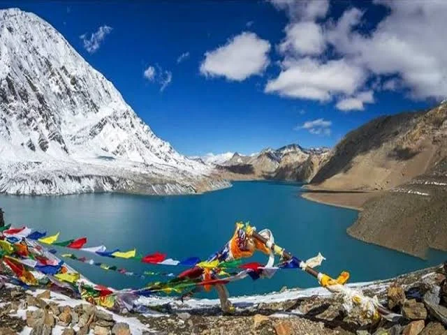
Every trek has one climax day, but not ACT. Annapurna Circuit Trek has two! One is the day when we cross the pass and one is today, when we start before the sun gets to work and amble our way to the electric blue glacial lake which delightfully owns the snow laden landscape high up at the altitude of 4,920M. It is an arduously steep climb, much on loose moraine.
We leave as early as 04:30 AM with our packed breakfast. We climb through dry mountains full of mud and gravel with the river down below and snow-clad mountains on the other side. Depending on how low the temperatures dipped to on the previous night, we might also find morning dew frozen solid on top of the few blades of grass on the side of the narrow trail and few of the last purple flowers you will see today. The air is dry and so is the terrain. When the sun comes up behind you, it is nothing short of magical – the sudden light on the trail, the properly defined rays from behind the mountains bringing everything in your surroundings to life. Landslides have broken some parts of the well-defined trail making them slippery and hard to walk on – rolling stones make it even more difficult. After walking the endless hairpin bends that the trail to this high-altitude lake is made of, we enter the snow area 2.5 hours into our day. After a steep and continuous ascend where we gain as much as 800M, we reach a sign board which indicates the way to Tilicho Lake. The sign post and the blue and white pole, which is used to mark the path all the way up to the lake, brings with it a sort of optimism that the lake is close by.
However, to believe that is only to seek disappointment for the lake is still an hour away as you cross one pole after the other after the other after the other! The terrain is mostly flat but full of shin-deep snow sitting in all shapes strangely carved so by the fierce winds of the altitude. The surface of the snow looks much like waves frozen in time – it is fascinating although endless! White is the only colour you see now until we get to the lake. Depending on the season and the snowfall, you will either find an electric blue lake waiting for you at the end of the trail or you find a massive field of ice smooth enough to play a game of ice hockey – and you can only imagine the lake as it would be under that thick sheet of ice. Either way, its beauty is inspiring to say the least. The 6 kms to the lake from the base camp take close to 3-4 hours. There is a board there which gives you all the details of the lake. The only colour you see around you is brought to you by the hundreds of prayer flags fluttering in the wind by the small temple that we find right before the lake.
After spending a bit of time here, we head back down to the base camp through the same route.
Today we descend down till Upper Khangsar village via Shreekharka. The trail is full of accents and descends as we witnessed while going up.
From Khangsar we merge down to the main trail of Annapurna circuit trek.
Not too long ago, Yak Kharka and Ledar were abandoned stone shelters, completely ignored by trekkers going up to Thorang Phedi. But ever since altitude’s starting getting a bit more respect, these places are being looked to as legit stop-holds by trekkers on their way to the foot of the pass. Since then, these places have seen the opening of some very comfortable lodges and decent cafes.
The gradient is not so steep, but it may feel difficult because of the altitude. Half an hour into our day and a 120M ascent, we get to the abandoned village which is now all but ruins of what once might have been a thriving local settlement. From the ruins you can see that you are once again moving towards greener pastures. The mountain below is cut out in steps to grow crops – hoards of wild yaks, horses and blue sheep loiter around as far as your eye can see.
An hour and half into our day, we reach to the top of a hill with the most magnificent view of what lies below. A meandering river snaking across the landscape, village at the foothills surrounded by lush green agricultural land spread out in various geometric patterns, the peculiar termite mound-like structures spread across the view – you can see the entire valley for kilometers ahead with Gangapurna, and Annapurna II, III, IV standing tall looking down at the same view as us. From here, we make a steep half an hour descent and lose all the height we gained and then some. Once we get all the way down, we cross over to the other side on a longish bridge swinging right above the river. Over to the other side, it’s all uphill from here. We once again have to make up for all the loss of altitude. There are a few tea stalls here just in case you need to regain some of that lost energy.
An hour and a half after we begin to ascend again, we are at Yak Kharka. The trail is well marked with coloured stripes on every rock you find on the way, so there is no question of getting lost. Yak Kharka has a few options if you want to have your lunch here. If you can hold out for one more hour, you can directly reach Ledar and have lunch there after you settle into your accommodation. Whichever you decide, make your decision quick since the sun packs up from Yak Kharka rather early which brings a sudden dip in temperatures making it a cold place to wait around at.
Yak Kharka to Ledar is barely any distance and on flat, open land too. There are yaks and horses all along the way, just going about their business. Ledar is right across the metal bridge you get to after a straight walk for not more than an hour. It is not a busy place, just a few lodges/ tea houses which might or might not be hosting a few trekkers depending on the season you visit.
Today isn’t all that long but it would help to get to High Camp as early as possible since options for accommodation at this altitude are slim (110 rooms) and fill up quick in high season. Although the route is not long, we start to feel the effects of altitude which is likely to slow us down.
We leave early by around 07:30 AM. After a steep ascent of 150M which takes close to 40 minutes to cover, we hit a small patch of descent and then a flat trail for 10 minutes. Stop and look behind or you are at a risk of missing yet another mesmerizing view of Annapurna III and Gangapurna blushing all shades of red in what is just another spellbinding Himalayan sunrise. The route is well marked all the way – look for red and white stripes on rocks which are marked at regular intervals. At the 50 minute mark, we reach a diversion. There are two paths, one which continues forward and one that goes down to the suspension bridge. Both of these take you to the same place so you can pick either. If you have developed a taste for swinging metal bridges, then this route would suit you well. For each route there is a steep incline after crossing over to the other side of the river – of only about 35M.
The 5 kms from Ledar to Thorang Phedi should take close to 2 to 2.5 hours. Encircling Thorang Phedi are ragged cliffs, crags and ridges. Phedi which is a Nepalese word, literally translates to ‘bottom of the pass’. There are options for stay at Thorang Phedi if you want to stay there. However, it is advised to climb up to High Camp so as to cut down on distance and altitude gain for tomorrow. It also is better for acclimatization since we cut down on sudden elevation gain tomorrow as we climb up to the pass.
Accommodation and food at both places are matched in quality so don’t let that be a decision for where you take a stop for today. High Pass is a 310M steep incline on crumbly but well-defined trail through the last boulder area for the day – it should take less than an hour. Since we get to Thorang Phedi by 10:30 AM, we have all day to leisurely climb up the 310M to High Pass – there is absolutely no rush. There are blue sheep everywhere to keep you company, too! But whether to go to High Pass on the same day is a decision which is left to the group based on how each person is feeling at the altitude and how confident each person feels about climbing higher up.
High Pass has 110 rooms which are either double or triple occupancy. There are 4 common toilets and one massive dining area divided in multiple sections. The kitchen serves all kinds of food like pancakes, pastas and pizzas and even beer! The wooden indoors are enough to keep you warm and unaffected by the cold wind outside. There is a short acclimatization walk which you can make on your own just to feel more ready to climb to the pass tomorrow and to expose yourself to the mountain wind at this altitude.
It does get busy in the dining area with people from everywhere who were previously scattered across different tea houses, now congregated in this one small space. Everyone doing their own thing – some socializing, some reading, some playing cards and everyone swapping stories – there is enough to do here!
We start early right after breakfast by around 5 AM. It still isn’t bright enough yet – we will be climbing in torchlight; so be extra cautious. The trail which zigzags up and up is extremely narrow and can get slippery with patches of ice and moraine. Make sure that you have enough battery in your head-torch for you might need it for at least the next 2 hours. If you stayed back at Thorang Phedi the previous night, you might have to leave even earlier and cover more distance in addition to gaining more height. So get your resources in place accordingly. It is important to carry at least two liters of water since the climb is extremely tiring and the air very dry – keeping your throat wet with water might help make it feel less scratchy. The first hour is truly tiring as you climb up a narrow gully in the thick of darkness. But with the first flush of dawn comes a new surge of energy as the glorious view makes an appearance. To look at these high mountains in the first light of the sun, it is so easy to naturally surrender to the beliefs of the locals about them being home to the Gods. Gangapurna and Annapurna III get flushed with the changing colours of the sun looking ever so glorious. Given that it is all a continuous and rather steep ascent, it helps to set a pace and maintain a rhythm.
The entire trail is through soft, dusty mountains which seem like you could blow them out of existence. After a series of humps, you start to see snow appearing in various patterns, chunks, stripes, and everything else you can think of. The view, for sure does its bit to keep you motivated to carry on in the cold. The last bit to the pass can be a bit of a frustration as a series of false summits make an appearance. But the 4 kms to the pass take not more than 3 hours. Remember never to take altitude too lightly, always be wary of your body and listen to what it’s trying to communicate to you.
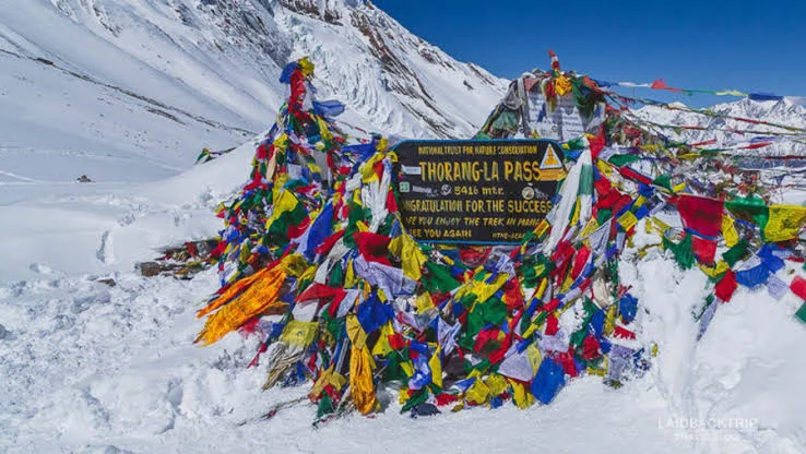
Look out for a mound of stones draped with numerous prayer flags. When you get to that and feel yourself being pushed in all directions by the deafening wind, know that you have reached the infamous Thorang La Pass. The wind here is icy and brutal, it wouldn’t be so bad to take some photos, have a brief celebration, have some hot tea at the tiny tea house at the pass – which seems to be the only place to provide some respite from the relentless winds – and start your descent. It is not a good idea to be exposed to these winds at this height for far too long. It’s going to be a long, hard, tiring journey down to Muktinath through miles and miles of deserted mountains with not a sign of any settlement into the far distance towards the horizon.
It is a good idea to stop and admire the magnificent landscape across the Kali Gandaki Valley as it changes form and colour. The trail snakes down the dry land on ridges and moraine. There are a lot of mountains to spot and name but the highlight is when the mighty Dhaulagiri makes an appearance. The trail, in places, may be soft and slippery due to broken sections from landslides. Look for red and white strikes to keep on the trail. You witness a constant change in scenery as we go back to green lands and hard rocks from these dusty mountains. At the end of this long descent, with quivering knees, the sense of achievement is rather indescribable. Remember at the end of the sharp and endless descends awaits a hot shower and some mouth-watering food! Oh and Wi-Fi is back!
Today early morning we pay an visit to Muktinath Temple and start our road journey to Pokhra. The drive is bumpy via offloading till Beni, after which we encounter through good highway till Pokhara.
After a hectic and strenuous trek, tonight is all about celebrations !!
Today after a scrumptious breakfast we check out from hotel and start our onward journey with a bag full of memories to cherish forever.
* Stay at a Lakeside hotel in Pokhra on Day 1 and Day 13 on sharing basis (2/3 person sharing)
*Stay on trek in Tea houses on sharing basis (3/4 person sharing a room with common toilet outside of room)
*Food starting from Day 2 breakfast till Day 14 Breakfast. 3 Times meals Breakfast, Lunch, Dinner with 2 times tea morning & evening. Veg/Non veg.
*Wifi at all the guest houses
*Mobile charging at all the guest houses
*Hot water to drink at all guest houses
*ACAP Permit fees
*Pokhra to Chame and Muktinath to Pokhra transportation cost
* 1 Boat ride at Phewa Lake on Day 13/Day 14
* 1 Mountaineering certified Hindi & English speaking Trek Leader
*Food during 1st day at Pokhra.
*Mineral water during trek
*Personal Bagpack offloading charges ( INR 8000 per bag for full trek – your bag should not weigh more than 10 kg )
*Compulsory tips to Guide, porters
*Transportation cost to reach hotel at Pokhra and onward journey from Pokhra Hotel
*Hot shower
*Emergency Evacuation and Rescue charges due ro any natural calamity, disaster or personal injury
*Any personal or group insurance
*Anything that is NOT mentioned under inclusions